

Land Boundary Monuments, Past and Present (4 of 6)
Monuments in Use Today on Public Lands
 Following
the use of stones for marking the corners of the public lands, the General
Land Office began the use of metal monuments. These were galvanized iron
pipes, with a split foot turned at right angles for a base, and a brass
cap riveted to the other end. The size of the pipe varied depending upon
the location of the corner in the section or township. A quarter corner
monument would be constructed with one inch (outside diameter) pipe. Section
corners and township corners were larger. Later, under the Bureau of Land
Management, a standard size with a large pipe and slightly different brass
cap construction was used, and is the type most commonly seen in the woods
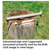
today. The commercial Copperweld monument, which is a copper clad steel
rod with a cap designed to be driven, was used after about 1950 for sixteenth
and lesser aliquot part corners. Aluminum monuments copying the large
BLM brass cap monuments are currently in use on public lands in at least
some instances. I obtained the BLM-style galavanized monuments from Schneidmiller
Industries in Colorado, and used a number of them in my private surveys.
Following
the use of stones for marking the corners of the public lands, the General
Land Office began the use of metal monuments. These were galvanized iron
pipes, with a split foot turned at right angles for a base, and a brass
cap riveted to the other end. The size of the pipe varied depending upon
the location of the corner in the section or township. A quarter corner
monument would be constructed with one inch (outside diameter) pipe. Section
corners and township corners were larger. Later, under the Bureau of Land
Management, a standard size with a large pipe and slightly different brass
cap construction was used, and is the type most commonly seen in the woods
today. The commercial Copperweld monument, which is a copper clad steel
rod with a cap designed to be driven, was used after about 1950 for sixteenth
and lesser aliquot part corners. Aluminum monuments copying the large
BLM brass cap monuments are currently in use on public lands in at least
some instances. I obtained the BLM-style galavanized monuments from Schneidmiller
Industries in Colorado, and used a number of them in my private surveys.
Characteristics Common to All Survey
Monuments
Monuments should have three characteristics, whether for public or private
use. These are:
1. The monument should be of durable material -- metal, stone, or concrete.
2. The monument should be readily identifiable by the public as a survey
monument.
3. The monument should be identifiable as a monument marking a particular
corner, and set by a particular surveyor.
Monuments--Past and Present--on Private Surveys
Monuments set to mark lines established by private surveyors over the
past hundred years range from the proverbial Model T axle (which I have
never found) to present day metal capped iron bars. The private corner
markers that I have found (other than townsite markers) and can identify
with certainty as original date from only about the turn of the century.
Montana law from early times specified that street intersections should be marked with a stone or metal monument. The earliest stone center line and townsite boundary markers which I have found (other than those at Virginia City which date from the late 1860s) date from about 1882. Those marking street center lines in downtown Helena are dressed rectangular granite stones with drill holes for the center point. I placed manhole rings and covers over those I found, and these stones can be found (hopefully) by referring to the plat which I filed in the early 1970s. Similar rectangular granite stones with drill holes were set in Manhattan, Montana, by Mr. Perry in the early eighties. These are still in existence. The street center lines of the original townsite of Wilsall were marked with angular sandstones with 1/4 inch diameter drill holes. Street center lines set after 1900 in Sheridan were smooth river boulders, as were the Clyde Park monuments, and were marked with a drill hole or "+." Unfortunately, water and sewer installations have removed many of these. It is surprising that we can still find as many as we do. The rectangular stones are about 5 inches by 12 inches in cross sections; the smooth boulders may be around 9 inches by 9 inches. If these are found, I strongly recommend that these be left in place, with reference monuments set some distance away in a safe place, and with a monument box over the stone, if possible. Surplus telephone access or sewer manhole rings and covers are excellent, and a city or town might supply these. Any reference monuments that are set too close to the stone may be mistaken for an attempt to remonument the corner!
I have found some street center lines which were marked shortly after 1900 with 2 inch diameter gas pipes or rectangular metal bars.
The monuments of choice for private work in the first half of the 20th century were iron pipes. These are usually 1/2 inch or 3/4 inch inside diameter. These usually have nothing to identify the surveyor or the location or the point which the pipe is intended to mark. Occasionally I have found larger pipes, although the large pipe with 12 inches above ground found now and then may be the work of a landowner, and may mark a less visible subsurface monument. Hopefully the landowner pipe has not been driven adjacent to the subsurface pipe, but too often the landowner seems to think that the closer it is set the better!
An early day surveyor working in southwestern Montana as county surveyor and private surveyor -- Mr. C. M. Thorpe -- left a considerable amount of well documented work. As county surveyor he marked many of the county road center line angle points with an iron pipe and lead sleeve slipped over the top of the pipe. The pipe would be about one inch outside diameter with a lead sleeve about one and a half inches long. The sleeves were cut from lead pipe, which was apparently easier to obtain then than it is now. He stamped a number on the sleeve using a chisel to mark Roman numerals or a stamp set using Arabic numerals, and placed the sleeve over the pipe, crimping if necessary. Some of these can be lifted off -- if this is done so that they can be photographed, the sleeves should be replaced (no souvenirs!).
| Home |
| The Best Kept Secrets in Montana Surveying Law |
| Curtis M. Brown, Land Surveyor and Author |
| How to Live in the Woods |
| Land Boundary Monuments, Past and Present |
| Solomon Meredith and the Initial Point of Montana |
